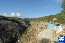
Wadi Amud Safed
One of the most popular hiking trails in Israel runs through Wadi Amud, the area below Tzfat which runs from the Eastern Galilee to the Jordan Valley.
Contents |
[edit] Geography
Wadi Amud descends from the mountains of the Eastern Galilee to the Jordan River. It runs for 22 kilometers. The lower part forms a canyon that is 100 meters wide with 75 meter high cliffs of eocene limestone walls. The area is filled with caves and cavities and the wadi was the subject of some of the first prehistoric archaeological and anthropological excavations in Israel.
[edit] Name
The name “Wadi Amud” derives from a limestone pillar that stands at the lower end of this limestone gorge. In Hebrew, “Amud” means “pillar” and the entire valley is referred to by this name that recognizes this natural wonder.
[edit] Caves
There are several caves in Wadi Amud, some created by the action of flowing water. These caves include the the Zuttiyeh cave, the Emireh Cave and the Amud cave, near the Amud pillar, where excavations uncovered skeletons and other ancient artifacts.
[edit] Landmarks
Hikers will note a number of historical landmarks through the wadi’s walk.
[edit] Kever Yehoyada Hakohen
Kever of Yehoyada Hakohen, head of the Sanhedrin and manager of the Kohanim during the reign of King Dovid is located right above the Sechvi Wadi. At times Yehoyada Hakohen would be the one to receive answers using the Urim Vitumim.
[edit] Kever Rabbi Nechunya ben HaKane
Kever of Rabbi Nechunya ben HaKane is located on the left side of the wadi right before the junction with Wadi Sechvi. Rebbe Nichunya ben HaKane was a Tana and the leading Kabbalist of his generation, he is known for his Kabbalistic text, the Bahir and for the prayer Anah Bekoach.
[edit] Kever Rabbi Abba from the Zohar
Rabbi Abba from the Zohar is buried in a cave on the right side of the wadi.
[edit] Police Station
An abandoned British police station is located on the southern bank of the wadi, visible when entering the wadi from Tzfat. The police station was built during the Arab uprisings of 1936-39 in order to protect the pumping station that brought water from the spring of Ein Yakim, which emanates from the channel of Nahal Meron, to Tzfat.
[edit] Fulling Mills
In the 15th century Jews who fled from the Spanish Inquisition brought the new technology of “fulling” to Tzfat. This process, executed at “fulling mills” located near water sources, allows a more efficient system of beating woven wool into felt as it tightens the threads and shrinks the fabric. Jews built fulling mills in Wadi Amud and remnants of these mills, along with the paving stones that allowed mules to bring the raw materials into and out of the wadi, can be seen throughout the wadi.
[edit] Pools
The trail through Wadi Amud follows a riverbed but meets up with several other water sources, including the Ein Yakim spring, the “Braichat HaMesushim” -- Hexagon Pool -- and the waterfalls that cascade down the canyon from the hidden spring of Ein Seter.
[edit] Plant and Animal Life
The wadi is full of plant and animal life. Hikers can see vultures which nest in the wadi as well as wild boar and other small mammals. The wadi also contains connate Alexanders (Smyrnium connatum) as well as funeral cypress trees, Egyptian Honesty plants, pistashio trees, almonds trees, yellow asphodels and olive and oriental plane trees.
[edit] Access
To enter Wadi Amud from Tzfat, hikers can descend through the ancient Tzfat cemetery (or skirt the cemetery along the southern cliff below the Ari Mikve). At the base of the cemetery, hikers must walk underneath the highway. The trail begins on the opposite side of the highway. The trail is marked with blue and white trail markers.
| |||||||||||||||||


